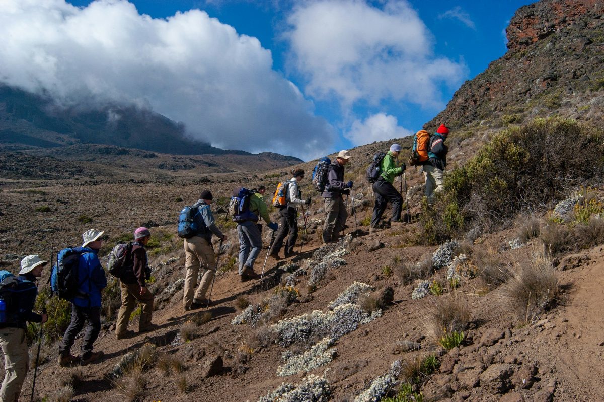
Only have six days to climb Kilimanjaro? Then Machame is your best choice, thanks to the way it helps you acclimatise. Compared with other six-day routes, Machame takes you higher sooner (on day three), which kickstarts your body's adjustment to altitude. You'll still need to be in good shape, though, to handle the tough climbs and descents.
Let's be honest: the six-day Machame is a hard route. Days four and five together make for a really demanding schedule. Day four is a full day of hiking from Barranco to Barafu. Then, after dinner and only part of a night's sleep, the long and gruelling summit day starts around midnight. All in all, the six-day Machame means 19-24 hours of demanding walking at extremely high altitude, with only 4-6 hours of sleep.
6 days on Machame
-
Day 1: Machame gate to Machame camp
- Hiking time
- 5-7 hours
- Distance
- 11 km
- Elevation
- 5,400ft to 9,400ft
- Habitat
- Rain Forest
It takes about 50 minutes to drive from Moshi to the Mount Kilimanjaro National Park Gate, passing through Machame village on the lower slopes of the mountain. From the park gate, we set off through the rainforest on a winding trail up a ridge. Lower down, the trail can be muddy and slippery, so gaiters and trekking poles are a good idea here. A little further on, we reach Machame Camp.
-
Day 2: Machame camp to Shira camp
- Hiking time
- 4-6 hours
- Distance
- 5 km
- Elevation
- 9,400ft to 12,500ft
- Habitat
- Moorland
After breakfast, we leave the glades of the rainforest behind and follow an uphill path, crossing a little valley and walking along a steep, rocky, heather-covered ridge until it runs out. Then the route turns west into a river gorge. Time to rest, have dinner and spend the night at the Shira campsite.
-
Day 3: Shira camp to Lava Tower to Barranco camp
- Hiking time
- 6-8 hours
- Distance
- 10 km
- Elevation
- 12,500ft to 13,000ft
- Habitat
- Semi Desert
From the Shira Plateau, we head east up a ridge, passing the junction towards the peak of Kibo. Then the trail turns south-east towards the Lava Tower, better known as the “Shark's Tooth”. Shortly after the tower comes a second junction, which leads up to the Arrow Glacier at 16,000ft. From there, we head down to the Barranco Hut at 13,000ft to rest, have dinner and spend the night. You'll finish the day at the same height you started, but don't let that fool you. This day is really important for acclimatisation, and it'll help your body get ready for summit day.
-
Day 4: Barranco camp to Karanga camp to Barafu camp
- Hiking time
- 8-10 hours
- Distance
- 9 km
- Elevation
- 13,000ft to 15,000ft
- Habitat
- Alpine Desert
After breakfast, we leave Barranco and climb a steep ridge past the Barranco Wall to the Karanga Valley campsite. From Karanga, we hit the junction that links up with the Mweka Trail and carry on up to the Barafu Hut. By now you've completed the South Circuit, which gives you views of the summit from lots of different angles. Here we set up camp, rest, have dinner and get ready for summit day. From this spot, you can see both of the mountain's peaks, Mawenzi and Kibo.
-
Day 5: Barafu camp to summit to Mweka hut
- Hiking time
- 7-8 hours ascent / 4-6 hours descent
- Elevation
- 15,300ft to 19,345ft (and down to 10,000ft)
- Habitat
- Arctic
You'll set off very early, somewhere between midnight and 2am, and make your way towards the summit between the Rebmann and Ratzel glaciers. Heading north-west, you'll climb through heavy scree towards Stella Point on the crater rim. This is the toughest part of the whole trek, both mentally and physically. At Stella Point (18,600 ft) you'll stop for a short rest, and if the weather plays along, you'll be rewarded with the most magnificent sunrise you're ever likely to see. From Stella Point, you might find snow all the way on the one-hour climb to the summit. And then you're there: Uhuru Peak, the highest point on Mount Kilimanjaro and in all of Africa! Faster hikers will catch the sunrise from the summit itself. From the top, we head straight back down to the Mweka Hut campsite, stopping at Barafu for lunch. You'll be glad of gaiters and trekking poles on the loose gravel going down. Mweka Camp sits in the upper forest, so expect mist or rain in the late afternoon. In the evening, we'll enjoy our last dinner on the mountain, followed by a very well-earned sleep.
-
Day 6: Mweka camp to Moshi
- Hiking time
- 3-4 hours
- Distance
- 10 km
- Elevation
- 10,000ft to 5,400ft
- Habitat
- Rain Forest
After breakfast, we carry on down to the Mweka Park Gate, where you'll receive your summit certificate. Lower down it can be wet and muddy, so gaiters and trekking poles will come in handy. Shorts and a t-shirt will probably be all you need to wear, but keep your rain gear and some warmer clothes close by. From the gate, it's another hour to Mweka Village, where a vehicle will be waiting to drive you back to your hotel in Moshi.
7 days on Machame
-
Day 1: Machame gate to Machame camp
- Hiking time
- 5-7 hours
- Distance
- 11 km
- Elevation
- 5,400ft to 9,400ft
- Habitat
- Rain Forest
It takes about 50 minutes to drive from Moshi to the Mount Kilimanjaro National Park Gate, passing through Machame village on the lower slopes of the mountain. From the park gate, we set off through the rainforest on a winding trail up a ridge. Lower down, the trail can be muddy and slippery, so gaiters and trekking poles are a good idea here. A little further on, we reach Machame Camp.
-
Day 2: Machame camp to Shira camp
- Hiking time
- 4-6 hours
- Distance
- 5 km
- Elevation
- 9,400ft to 12,500ft
- Habitat
- Moorland
After breakfast, we leave the glades of the rainforest behind and follow an uphill path, crossing a little valley and walking along a steep, rocky, heather-covered ridge until it runs out. Then the route turns west into a river gorge. Time to rest, have dinner and spend the night at the Shira campsite.
-
Day 3: Shira camp to Lava Tower to Barranco camp
- Hiking time
- 6-8 hours
- Distance
- 10 km
- Elevation
- 12,500ft to 13,000ft
- Habitat
- Semi Desert
From the Shira Plateau, we head east up a ridge, passing the junction towards the peak of Kibo. Then the trail turns south-east towards the Lava Tower, better known as the “Shark's Tooth”. Shortly after the tower comes a second junction, which leads up to the Arrow Glacier at 16,000ft. From there, we head down to the Barranco Hut at 13,000ft to rest, have dinner and spend the night. You'll finish the day at the same height you started, but don't let that fool you. This day is really important for acclimatisation, and it'll help your body get ready for summit day.
-
Day 4: Barranco camp to Karanga camp
- Hiking time
- 4-5 hours
- Distance
- 5 km
- Elevation
- 13,000ft to 13,100ft
- Habitat
- Alpine Desert
After breakfast, we leave Barranco and climb a steep ridge past the Barranco Wall to the Karanga Valley campsite. It's a short day, and that's on purpose: it's all about helping you acclimatise.
-
Day 5: Karanga camp to Barafu camp
- Hiking time
- 4-5 hours
- Distance
- 4 km
- Elevation
- 13,100ft to 15,300ft
- Habitat
- Alpine Desert
After breakfast, we leave Karanga and hit the junction that links up with the Mweka Trail, then carry on up to the Barafu Hut. By now you've completed the South Circuit, which gives you views of the summit from lots of different angles. Here we set up camp, rest, have dinner and get ready for summit day. From this spot, you can see both of the mountain's peaks, Mawenzi and Kibo.
-
Day 6: Barafu camp to summit to Mweka hut
- Hiking time
- 7-8 hours ascent / 4-6 hours descent
- Elevation
- 15,300ft to 19,345ft (and down to 10,000ft)
- Habitat
- Arctic
You'll set off very early, somewhere between midnight and 2am, and make your way towards the summit between the Rebmann and Ratzel glaciers. Heading north-west, you'll climb through heavy scree towards Stella Point on the crater rim. This is the toughest part of the whole trek, both mentally and physically. At Stella Point (18,600 ft) you'll stop for a short rest, and if the weather plays along, you'll be rewarded with the most magnificent sunrise you're ever likely to see. From Stella Point, you might find snow all the way on the one-hour climb to the summit. And then you're there: Uhuru Peak, the highest point on Mount Kilimanjaro and in all of Africa! Faster hikers will catch the sunrise from the summit itself. From the top, we head straight back down to the Mweka Hut campsite, stopping at Barafu for lunch. You'll be glad of gaiters and trekking poles on the loose gravel going down. Mweka Camp sits in the upper forest, so expect mist or rain in the late afternoon. In the evening, we'll enjoy our last dinner on the mountain, followed by a very well-earned sleep.
-
Day 7: Mweka camp to Moshi
- Hiking time
- 3-4 hours
- Distance
- 10 km
- Elevation
- 10,000ft to 5,400ft
- Habitat
- Rain Forest
After breakfast, we carry on down to the Mweka Park Gate, where you'll receive your summit certificate. Lower down it can be wet and muddy, so gaiters and trekking poles will come in handy. Shorts and a t-shirt will probably be all you need to wear, but keep your rain gear and some warmer clothes close by. From the gate, it's another hour to Mweka Village, where a vehicle will be waiting to drive you back to your hotel in Moshi.
The day-by-day details (hiking times, distances, habitats and elevations) come straight from our original Kilimanjaro page. We've rewritten the descriptions to read more easily, without changing the facts. Elevations appear where that page gave them, in the units it used.
Fancy a different way up?

Lemosho Route
Why do we prefer the seven-day Lemosho to the six-day version? Because it splits day two into two days, which gives you better acclimatisation and a more gradual climb. On…

Marangu Route
Marangu is one of the most popular routes to the top of Kilimanjaro. Why? Partly because it's the least expensive route, but probably more because you can do it in…

Rongai Route
The Rongai route climbs Kilimanjaro from the north-eastern side of the mountain, along the border between Tanzania and Kenya. It still feels like unspoilt wilderness, and approaching from the north…